Posts

Showing posts from August, 2024

Topic 10: Earthquakes

Image
EARTHQUAKES Definition and Causes Earthquakes are the shaking of the Earth’s surface caused by the sudden release of energy from the Earth’s crust. This release of energy typically occurs along faults, which are fractures or zones of weakness in the Earth’s crust. The movement of tectonic plates—large pieces of the Earth’s crust—due to geological processes, such as subduction or rifting, is the primary cause of earthquakes. Measurement and Impact Earthquakes are measured using seismographs, which record the intensity and duration of ground shaking. The magnitude of an earthquake is often reported on the Richter scale or the Moment Magnitude Scale (Mw), which quantifies the energy released. Earthquakes can cause significant damage to infrastructure, leading to building collapses, landslides, and tsunamis, which can have devastating effects on communities and environments. Preparedness and Mitigation Understanding earthquake risks is crucial for effective preparedness and mitigation. Bui

topic 9: Volcanoes

Image
VOLCANOES Definition and Types  Volcanoes are openings in the Earth’s crust through which magma, ash, and gases can escape. They are classified into several types, including shield volcanoes, stratovolcanoes, and cinder cone volcanoes. Mount Vesuvius in Italy is famous for its eruption in 79 AD that buried Pompeii. Mount St. Helens in the USA erupted dramatically in 1980, altering the surrounding landscape. Kilauea in Hawaii is one of the world’s most active volcanoes. Volcanic Impact   Volcanic eruptions can have profound effects on the environment, including altering landscapes, affecting climate, and impacting human settlements. Volcanic ash and lava contribute to soil fertility, making volcanic regions often ideal for agriculture despite their initial hazards. Volcanic hazards include pyroclastic flows, ashfall, and volcanic gases, which can pose risks to health and infrastructure. Monitoring and Prediction Volcano monitoring involves using seismographs, satellite imagery, and gas

Topic 8: Islands

Image
ISLANDS Types and Formation Islands are land masses completely surrounded by water. They can form through volcanic activity, sediment deposition, or tectonic movements. There are oceanic islands, which arise from volcanic activity, and continental islands, which are part of the continental shelf. Madagascar, located off the southeastern coast of Africa, is known for its unique biodiversity. The Hawaiian Islands in the Pacific are volcanic islands with diverse ecosystems. Greenland, the world’s largest island, is largely covered by ice. Human Impact Islands often have distinct ecosystems and cultures. Human activities, such as tourism and development, can significantly impact these unique environments. Conservation efforts are important to preserve the biodiversity and cultural heritage of island regions. Protecting island environments involves managing invasive species, preserving natural habitats, and promoting sustainable tourism practices to safeguard both biodiversity and local cul

topic 7: Climate Zones

Image
CLIMATE ZONES Definition and Classification Climate zones are regions of the Earth classified based on their long-term weather patterns and temperatures. The primary climate zones include tropical, dry, temperate, polar, and highland climates. Types of Climate Zones Tropical Climate: Tropical climates are characterized by high temperatures and significant rainfall throughout the year. Regions such as the Amazon Rainforest experience this type of climate, which supports lush vegetation and diverse wildlife. Polar Climate: Polar climates are found near the poles and are known for their cold temperatures and limited precipitation. The Arctic and Antarctic regions have polar climates, where ice and snow dominate the landscape. Highland climates are found in mountainous regions, where temperatures and precipitation can vary with altitude. These areas often experience cooler temperatures and more precipitation than surrounding lowlands. Dry climates include arid and semi-arid regions, charac

Topic 6: Lakes

Image
LAKES Formation and Types  Lakes are large bodies of freshwater surrounded by land. They can form through various geological processes, including tectonic activity, volcanic activity, and glacial movement. Lakes are categorized as natural or artificial. Lake Superior, one of the Great Lakes in North America, is the largest by surface area. Lake Victoria in Africa is the second-largest and is crucial for regional biodiversity. The Caspian Sea, although called a sea, is technically the world’s largest lake. Water Supply  Lakes are important sources of drinking water for many regions and play a critical role in water management systems.  They support various species of fish, birds, and plants, and often play a key role in local climate regulation and water cycles. Lakes also provide recreational opportunities such as boating, fishing, and swimming, which can impact their ecosystems and require sustainable  management practices. Climate Regulation  Lakes can influence local climates by mod

topic 5: Deserts

Image
Deserts Deserts are regions that receive very little precipitation, typically less than 10 inches annually. They are characterized by extreme temperature variations, from scorching daytime heat to cold nights. Common types of deserts include hot deserts and cold deserts. The Sahara Desert in Africa is the largest hot desert, known for its vast sand dunes. The Gobi Desert in Asia is a cold desert with harsh winters. The Atacama Desert in South America is one of the driest places on Earth. Adaptations and Life Desert ecosystems are adapted to extreme conditions, with plants and animals having specialized adaptations for conserving water and surviving temperature fluctuations. Despite harsh conditions, deserts host specialized flora and fauna adapted to extreme dryness. Plants like cacti store water in their tissues, and animals such as camels have evolved to survive with minimal water. Human Adaptations and Economic Activities Humans living in desert regions use techniques like oasis far

Topic 4: Rivers

Image
RIVERS Rivers are flowing bodies of freshwater that usually drain into seas or oceans. They play a vital role in shaping landscapes, providing water for agriculture, and supporting ecosystems. Major rivers often serve as important trade routes. Rivers are vulnerable to pollution from industrial discharge, agricultural runoff, and urban waste, which can affect water quality and aquatic life. River Basins River basins, or watersheds, are the areas of land drained by a river and its tributaries. They are crucial for managing water resources and mitigating flood risks. The Nile River in Africa is one of the longest rivers in the world, crucial for agriculture in Egypt. The Amazon River in South America is the largest by volume and supports the Amazon Rainforest. The Mississippi River in North America is significant for its historical and economic impact. Ecological Impact Rivers are essential for maintaining freshwater ecosystems and supporting a variety of wildlife. Rivers often hold cult

Topic 3: Mountains

Image
MOUNTAINS  Formation and Types Mountains are elevated landforms created by geological processes such as tectonic plate movements. There are three main types: fold mountains (e.g., the Himalayas), volcanic mountains (e.g., Mount Fuji), and block mountains (e.g., the Sierra Nevada). The Himalayas in Asia are known for their extreme heights and include Mount Everest, the highest peak in the world. The Andes in South America form the longest continental mountain range, extending over 4,000 miles. The Rocky Mountains in North America are known for their rugged terrain. Erosion and Weathering Mountains undergo erosion and weathering, which shape their appearance and affect soil fertility. Glaciers, wind, and water contribute to this process. Mountain regions support diverse ecosystems ranging from temperate forests to alpine tundra, with species adapted to varying elevations and climates. Tourism and Recreation Mountain regions are popular for activities such as hiking, skiing, and climbing,

Topic 2: Oceans

Image
OCEANS What is an Ocean   An ocean is a large, body of water between continents. Oceans are extremely big and they join smaller seas together. Oceans (or marine) cover 70% of Earth. There are five main oceans: the Pacific Ocean, the Atlantic Ocean, the Indian Ocean, the Southern Ocean, and the Arctic Ocean. The largest ocean is the Pacific Ocean. The smallest ocean is the Arctic Ocean. While Many types of animals live in oceans, such as carp, crabs, starfish, sharks, and whales. Different water movements separate the Southern Ocean from the Atlantic, Pacific and Indian Oceans. The Southern Ocean is also called the Antarctic Ocean, because it covers the area around Antarctica. These vast bodies of saltwater play a crucial role in regulating the planet’s climate and weather patterns. Oceans are rich in resources, including fish, oil, and gas. They are also sources of minerals like salt and manganese nodules. Ocean Currents Ocean currents, such as the Gulf Stream and the Kuroshio Current,

Topic1: Continents

Image
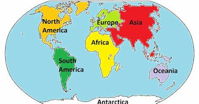
CONTINENTS Definition and Distribution Continents are large continuous masses of land, typically divided by oceans and seas. There are seven continents on Earth: Africa, Antarctica, Asia, Europe, North America, Australia (Oceania), and South America. Each continent has its own distinct geographic and cultural characteristics. Geological formation of continents; continents were formed through tectonic plate movements and volcanic activity over millions of years. Their current arrangement is a result of the shifting and colliding of Earth's crustal plates. Climate Variability Each continent experiences a range of climates, from the icy expanses of Antarctica to the tropical rainforests of South America. This diversity affects local weather patterns and ecosystems. Continents host unique flora and fauna, shaped by their varied climates and geographies. For example, Australia is home to marsupials like kangaroos, while Africa has iconic megafauna such as elephants and lions. Human Sett